


099B - BLAKELY Voting District, Early County, Georgia
About
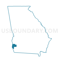
Outline

Summary
| Unique Area Identifier | 561348 |
| Name | 099B - BLAKELY Voting District |
| County | Early County |
| State | Georgia |
| Area (square miles) | 38.86 |
| Land Area (square miles) | 38.65 |
| Water Area (square miles) | 0.21 |
| % of Land Area | 99.45 |
| % of Water Area | 0.55 |
| Latitude of the Internal Point | 31.37736260 |
| Longtitude of the Internal Point | -84.91692440 |
Maps


Graphs
Select a template below for downloading or customizing gragh for 099B - BLAKELY Voting District, Early County, Georgia


Neighbors
Neighoring Voting District (by Name) Neighboring Voting District on the Map
- 099A - ARLINGTON Voting District, Early County, GA
- 099CO - COLOMOKEE Voting District, Early County, GA
- 099CUBA - CUBA Voting District, Early County, GA
- 099D - DAMASCUS Voting District, Early County, GA
- 099F - FREEMAN Voting District, Early County, GA
- 099H - HILTON Voting District, Early County, GA
- 099L - LUCILE Voting District, Early County, GA
- 099U - URQUHART Voting District, Early County, GA
Top 10 Neighboring County Subdivision (by Population) Neighboring County Subdivision on the Map
Top 10 Neighboring Place (by Population) Neighboring Place on the Map
Top 10 Neighboring Unified School District (by Population) Neighboring Unified School District on the Map
Top 10 Neighboring State Legislative District Lower Chamber (by Population) Neighboring State Legislative District Lower Chamber on the Map
Top 10 Neighboring State Legislative District Upper Chamber (by Population) Neighboring State Legislative District Upper Chamber on the Map
Top 10 Neighboring 111th Congressional District (by Population) Neighboring 111th Congressional District on the Map
Top 10 Neighboring Census Tract (by Population) Neighboring Census Tract on the Map
- Census Tract 904, Early County, GA (3,523)
- Census Tract 902, Early County, GA (2,670)
- Census Tract 903, Early County, GA (1,535)
- Census Tract 901, Early County, GA (1,438)